WEEK #16: FINAL BLOG
WEEK#16 FINAL BLOG
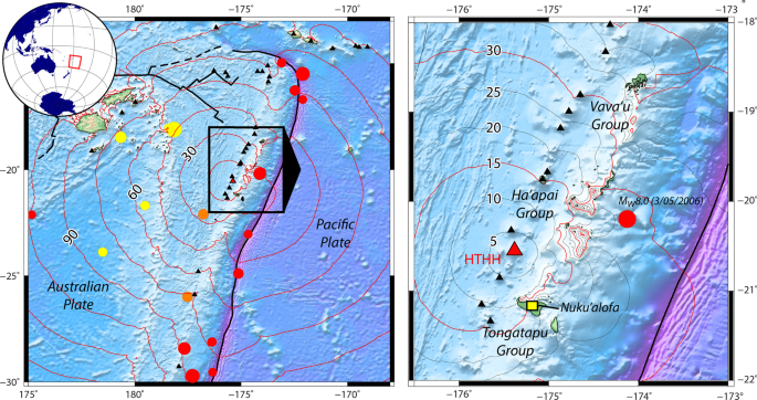
Tonga is vulnerable to a number of natural hazards due to its location and topographical nature. Given its levels of exposure to the aforementioned hazards, the Kingdom of Tonga holds second place among 172 countries covered by the World Risk Index 2018.Tonga sits at the junction of two major tectonic plates the Indo-Australian plate in the West and the Pacific Plate in the East. It is part of the Pacific “Ring of Fire” that encircles the entire ocean basin.
Tonga's two most dangerous hazards are tsunamis and tropical cyclone. A tsunami is caused from anything that rapidly displaces a large volume of water. Typically, tsunamis are caused by underwater earthquakes, but landslides, volcanic eruptions, calving icebergs, and (very rarely) meteorite impacts can also generate tsunamis. These types of events can cause large disturbances in the surface of the ocean causing large volumes of water to move.
A tsunami happen due to its location. HTHH is an active stratovolcano formed as a result of westward subduction of the Pacific tectonic plate beneath the Australian Plate along the Tonga-Kermadec (TK) submarine trench. It is important to analyze the Catastrophic it causes destroying hundreds of structures, and displacing many people, and causing deaths.
Tonga's southwestern location bordering the Pacific "Ring of Fire" increases its risk to tsunamis.This area of high tectonic activity.
Tsunami Mitigation
It is difficult to give a lot of warning for a tsunami so the best you can do is prepare as best you can by doing the following:
* Prepare a family response plan and know where to evacuate to in the event of a tsunami warning, ideally move inland at least 2 km
* Prepare an emergency kit, including a battery operated radio, food and drinking water for at least 3 days, spare clothes, torch and spare batteries. Keep a list of emergency numbers handy.
* Listen for official tsunami warnings through sirens, loudspeakers, radio, television, SMS and Internet that Tonga Meteorological Service (www.met.gov.to) may issue.
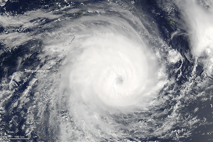
The second most dangerous hazard in Tonga is a tropical cyclone. A tropical cyclone is a low-pressure system which develops in the tropics with sustained gale force winds of at least 63km/hour.
There is a higher risk of Tongatapu and Eua being affected by a tropical cyclone this season than other parts of Tonga.

Tropical Cyclone Mitigation
Given the nature of cyclones, it is difficult to accurately predict how many and at what intensity will directly impact Tonga. It is always better to be over-prepared than under-prepared, and keep up to date with the latest weather forecasts. Here are some things you can do to prepare you and your family:
* Trim tree branches well clear of your home and clear your property of loose material that could cause injury or damage during extreme winds.
* Secure your roof and fit window shutters (or at least metal bars or screens to keep airborne objects out.
* Have an emergency kit on hand, including a battery operated radio, enough food and drinking water for at least three days, spare clothes, torch and spare batteries. Keep a list of emergency numbers handy.
* Listen to progress of a cyclone through information distributed through radio, TV, and SMS and internet messages provided by the Tonga Meteorological Service.
* Depending on predicted wind speeds and storm surge heights, evacuation may be necessary. Be prepared early to evacuate immediately you are told to and know where you are going to go. This could be to family and friends or to an evacuation centre. Official advice may be provided on local radio/TV/SMS about safe routes and when to move.
Due to the location of Tonga the Natural hazards discussed above are inevitable but when can follow mitigating efforts to assure we are prepared if any hazards happen. If I was constructing a house in Tonga it would probably be in Niuatoputapu Island in the most highest elevated area. Niuatoputapu Island has higher elevations and it is away from areas exposed to coastal hazards. Niuatoputapu island nonetheless appears to benefit from the coral reef surrounding the island, which protected the villages from excessive run-up. In addition to that Tsunami amplitudes can be mitigated by the presence of healthy coral reefs.
SOURCES
2021-2022-tropical-cyclone-season-outlook-tonga-ento
tropical-cyclone-gita-slams-tonga


Comments
Post a Comment