Week #3 QUAKES
WEEK #3 QUAKES
An earthquake is the shaking of the surface of the Earth resulting from a sudden release of energy in the Earth's lithosphere that creates seismic waves.Wikipedia
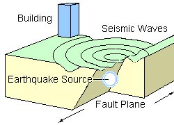
When an earthquake occurs, stress accumulated in solid rock is suddenly released along fault lines. The energy released when the rocks break along the fault is converted into seismic waves that radiate from the origin. earthquake-illustration.jpg
seismicity, the worldwide or local distribution of earthquakes in space, time, and magnitude. More specifically, it refers to the measure of the frequency of earthquakes in a region. www.britannica.com
Tonga eruption seismicity and seismic stations

The three closest seismic stations (red inverted triangles) to the Tonga eruption are more than ~760 km (~472 mi) away. (b) The timeline of earthquakes (yellow circles) at the Tonga eruption site shows the increase of seismicity immediately after the M5.8 during the initial eruption usgs.gov
According to the United States Geological Survey, the quake hit on Saturday, February 11th, 2023, at 6:06 am local time at a shallow depth of 10 km. Shallow earthquakes are felt more strongly than deeper ones as they are closer to the surface. The exact magnitude, epicenter, and depth of the quake might be revised within the next few hours or minutes as seismologists review data and refine their calculations, or as other agencies issue their report.
Generally quakes of this magnitude are recorded by more than one agency and the results can vary, with subsequent reports that come in after the first one often showing more accuracy.
Based on the preliminary seismic data, the quake should not have caused any significant damage, but was probably felt by many people as light vibration in the area of the epicenter.
Weak shaking might have been felt in 'Ohonua (pop. 1,200) located 131 km from the epicenter. mag5quake-Feb-10-2023-Tonga-Islands.html

5.3 quake 11 Feb 6:06 am (GMT +13)


Comments
Post a Comment